Jabal Mahama (1042m), Wadi Khasab, Musandam, Oman.
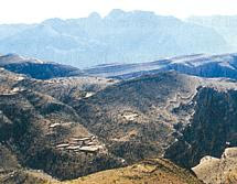
 View south from Jabal Harem (ca. 2100m, also known as Jabal as Sayh). The highest summit on the Musandam Peninsula, Oman.
 On the ridge of Ra's Awlad (ca. 300m), Wadi Khasab, Musandam, Oman.
 View south from Jabal Harem (ca. 2100m, also known as Jabal as Sayh). The highest summit on the Musandam Peninsula, Oman.
 Full moon over Khor Najd, evening, near Khasab, Musandam Fijords, Oman, Arabian Peninsula

 View south from Jabal Harem (ca. 2100m, also known as Jabal as Sayh). The highest summit on the Musandam Peninsula, Oman.
  On the ridge of Ra's Awlad (ca. 300m), Wadi Khasab, Musandam, Oman.
  View south from Jabal Harem (ca. 2100m, also known as Jabal as Sayh). The highest summit on the Musandam Peninsula, Oman.
  Full moon over Khor Najd, evening, near Khasab, Musandam Fijords, Oman, Arabian Peninsula
The Musandam peninsula. The rocks rise straight out of the sea.
View south from Jabal Harim, over 1,500 m high.
Shelly fossils in limestone at 1,500m on Jabal Harim. View north down Wadi Khasab.


View south from Jabal Harim, over 1,500 m high.

Shelly fossils in limestone at 1,500m on Jabal Harim.
 View north down Wadi Khasab.